


ElevMaps
ElevMaps의 설명
ElevMaps는 간단하고 쉬운 사용자 인터페이스를 갖춘 강력한 GPS 도구입니다.
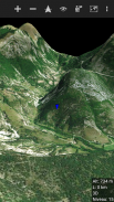
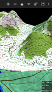
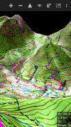
ElevMaps는 하이킹 여행을위한 3D / 2D지도 뷰어입니다.
ElevMaps는 산악 자전거, 패러 글라이드 및 많은 야외 활동에도 적합합니다 ...
3D지도는 OpenGL에서 다양한 소스의지도 타일을 결합하여 렌더링됩니다.
고도 데이터.
지도는 클래식지도 (북쪽 위로) 또는 자동 회전으로 표시 할 수 있습니다
(GPS 방향 및 나침반 방향)
ElevMaps는 훌륭한지도 내비게이션 GPS 도구이기도합니다 ... 절대 잊지 못할 것입니다!
현재 기능 :
. 온라인 및 오프라인지도를 3D 및 2D로 볼 수 있습니다.
. 오프라인 사용을 위해 맵 영역을 다운로드하십시오.
. 모바일지도 작성기 (MOBAC)와 함께 다운로드 한 오프라인지도보기
아틀라스 형식은 OSMAND 타일 저장 공간입니다.
. 다른 렌더링 테마를 사용하여 Mapsforge 맵 / OpenAndroMap 맵을 봅니다.
. 줌 레벨 명령 입 / 출력 및 화면 손가락 제스처 통합으로 완벽한지도보기.
. OziExplorer 맵 가져 오기 및보기.
. 현재 다운로드 한지도의 고도를 다운로드하여 첨부하십시오.
. SRTM3 형식의 고도 데이터 사용 (장치에 저장되어 큰지도에 적합)
. KML / GPX 형식으로 기록을 추적합니다.
. KML / GPX 형식의 간편한 여행 준비를위한 트랙 작성기.
. 하이킹 모드 또는 항공 모드 3D (KML / GPX 형식)로 플레이어 추적
. KML / GPX 형식의 트랙 가져 오기 / 내보내기.
. 통계 창 (고도, 속도, 거리 ...)
. 지도에서 장소 검색 (인터넷 필요)
. 곧 출시 될 더 많은 기능 ...
ElevMaps - 버전 1.7.33
(05-01-2025)ElevMaps의 최신 버전
다른 버전들


동일 카테고리의 앱


